
Bermuda faces trouble from Humberto and Imelda as storms take similar paths
With Humberto producing dangerous surf and rip currents for Bermuda and most of the U.S. East Coast, Imelda is forecast to become a hurricane by Tuesday morning and will ultimately take a similar path in behind Humberto
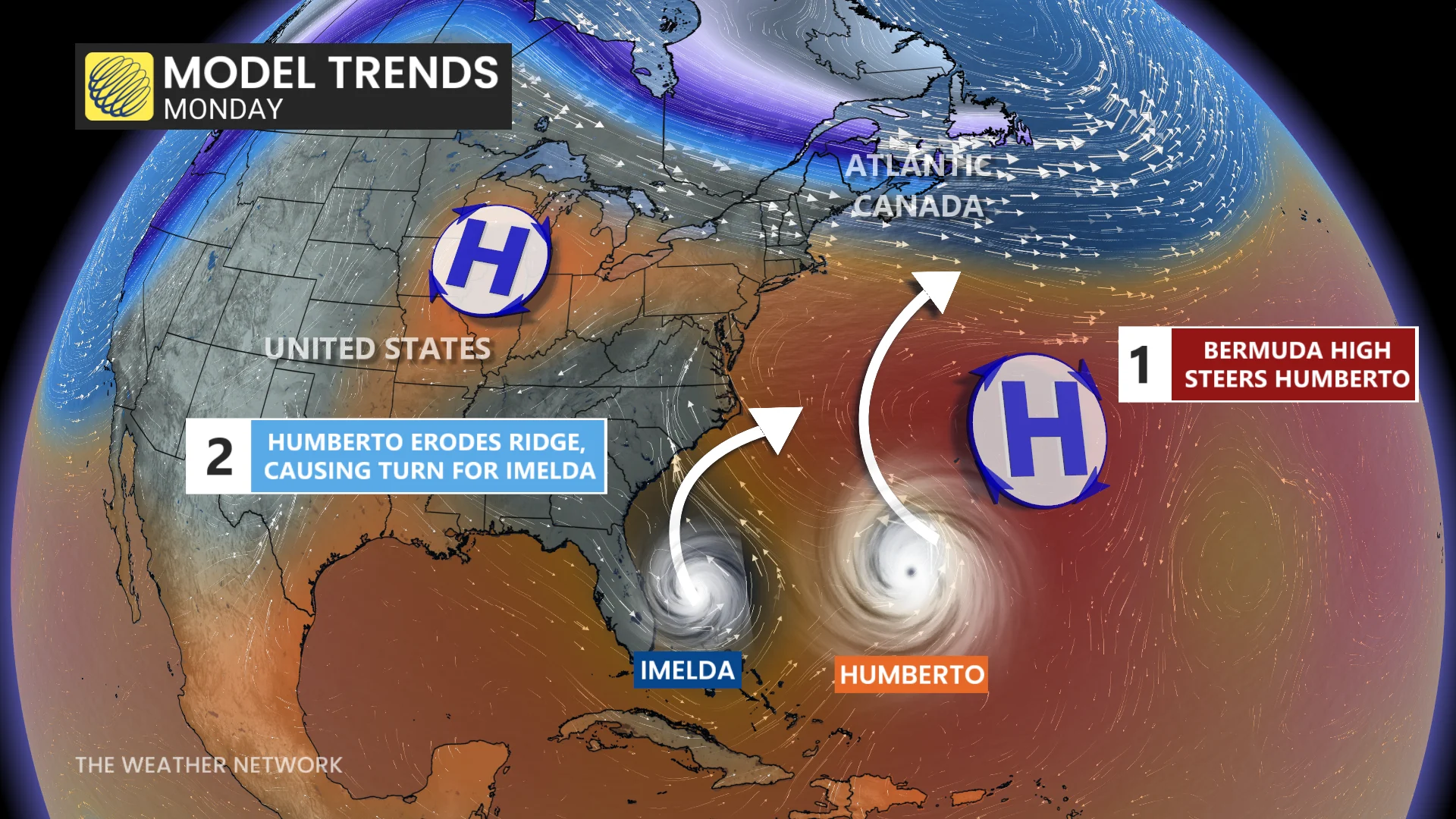
Where Hurricane Humberto goes this week, Tropical Storm Imelda will similarly follow.
It might sound like a puzzle but it's a consequence if two tropical systems get too close to each other, a case that has happened with the aforementioned storms. Dubbed the Fujiwhara effect, the phenomenon occurs when two storms get close enough together that they begin to interact with one another.
DON'T MISS: The incredible history and tools of the Hurricane Hunters
Humberto is currently producing dangerous surf and rip currents for Bermuda, and most of the U.S. East Coast, while Imelda is forecast to become a hurricane Tuesday morning and will ultimately take the same path in behind Humberto, also set to bring impacts to Bermuda.
Humberto still a powerful Category 4 hurricane
Despite losing some strength, the intense Humberto continued to pack maximum and sustained winds of 220 km/h as of Monday evening, maintaining its Category 4 status. Weakening is forecast over the next several days, although Humberto is expected to remain a dangerous major hurricane into Tuesday.

Forecasters with the U.S. National Hurricane Center (NHC) expect the storm to recurve out to sea through this week, steered along by a strong ridge of high pressure parked over the central Atlantic.
The hurricane is forecast to turn and accelerate east-northeastward by late Tuesday or early Wednesday. On the forecast track, the centre of Humberto will pass west, and then north of Bermuda on Tuesday and Wednesday. It will then transition into a large, extratropical storm in the North Atlantic on Thursday.

The tropical storm watch has been replaced by a hurricane watch in Bermuda due to the expected impacts from Imelda. However, gusty winds are possible from Humberto over Bermuda within outer rain bands Tuesday into Wednesday.
As well, dangerous rip currents are expected across the northern Caribbean, Bahamas, Bermuda and the U.S. East Coast this week as Humberto continues to churn through the region.
WATCH:How the Fujiwhara effect can send hurricanes spinning off course
Imelda will become a hurricane on Tuesday
Imelda’s structure is improving, with more symmetric banding around the centre. NOAA Hurricane Hunter aircraft data confirmed intensification, with the system forecast to become a hurricane by Tuesday morning.
A hurricane watch has been issued in Bermuda ahead of the expected impacts from Imelda, while a tropical storm warning continues. The tropical storm made its long-anticipated appearance over the Bahamas on Sunday as the system gradually got its act together.
RELATED: Hurricane terms everyone should know as the season heats up
Maximum, sustained winds have increased to near 100 km/h with higher gusts. Additional strengthening is forecast over the next few days, and Imelda is forecast to become a hurricane on Tuesday morning.

The system’s slow development, and slow forward movement, will likely prove beneficial for the southeastern U.S. coast. Hurricane Humberto will cause a weakness in that ridge of high pressure over the Atlantic, providing Imelda an off-ramp of sorts to make a hard turn toward the east.
On Tuesday, Imelda is expected to turn sharply to the east-northeast and accelerate. On the forecast track, the centre of the system should move away from the northwestern Bahamas and then turn east-northeastward, moving away from the southeastern U.S. but approaching the island of Bermuda on Wednesday.
This sharp deviation will significantly reduce the amount of wind and rain expected along the U.S. coast.

Tropical Storm Imelda is expected to produce additional rainfall of 25 mm to 75 mm across the northwest Bahamas through Monday night. This rainfall may produce flash and urban flooding.
Storm total rainfall amounts of 25 mm to 50 mm, with local maximum totals of 100 mm, are expected through Monday night across northeast Florida, coastal South Carolina, and coastal sections of southeast North Carolina. This rainfall could result in isolated flash and urban flooding.
However, the turn of Imelda could also put Bermuda directly in the storm’s path by the latter half of this week. As Imelda passes near Bermuda, 50 mm to 100 mm of rainfall is expected from Wednesday into Thursday, the NHC says.
Interests on the island should pay close attention to forecast updates in the days ahead.