
Are you ready for 'Snow'vember? Snowfall threat looms over Canada
All but two provinces are forecast to kick off November on a snowy note!
From British Columbia's mountain passes all the way to Labrador, November across Canada is looking at an overwhelmingly snowy start.
After warm, late-October air dominated over parts of Northern Canada, setting records in Nunavut for the warmest October on record, a mass of Arctic air will drive south over the coming days, ushering in cold, wintry air that will fuel this week's snow threat across the entire country.
RELATED: Canada's November features extended fall, but winter lurks on the sidelines
Only two provinces are forecast to stay out of the snow, but for everyone else, grab the winter jackets and dust off your snow shovels!

The forecast in each region is unique, so let's begin in the west.
British Columbia
B.C. has been no stranger to snowy weather already this season. The province's mountains easily accumulate alpine snow this time of year thanks to Pacific moisture sweeping over the high-elevation terrain.
An active jet stream over the Pacific will continue to direct moisture onshore, bringing rounds of heavy snow to higher elevations on Monday night and again on Wednesday.

Prairies
The Pacific moisture over B.C. will lend a hand in fuelling the snow threat over the Prairies this week, as the atmospheric moisture and energy carried by the jet stream will cross over the Rocky Mountains and trigger the development of a clipper system over Alberta by late Wednesday.
SEE ALSO: Snowy surprises can blanket Canada during a typical November
The clipper is forecast to drop snow over the northern and central Prairies, impacting the Yellowhead Highway corridor.
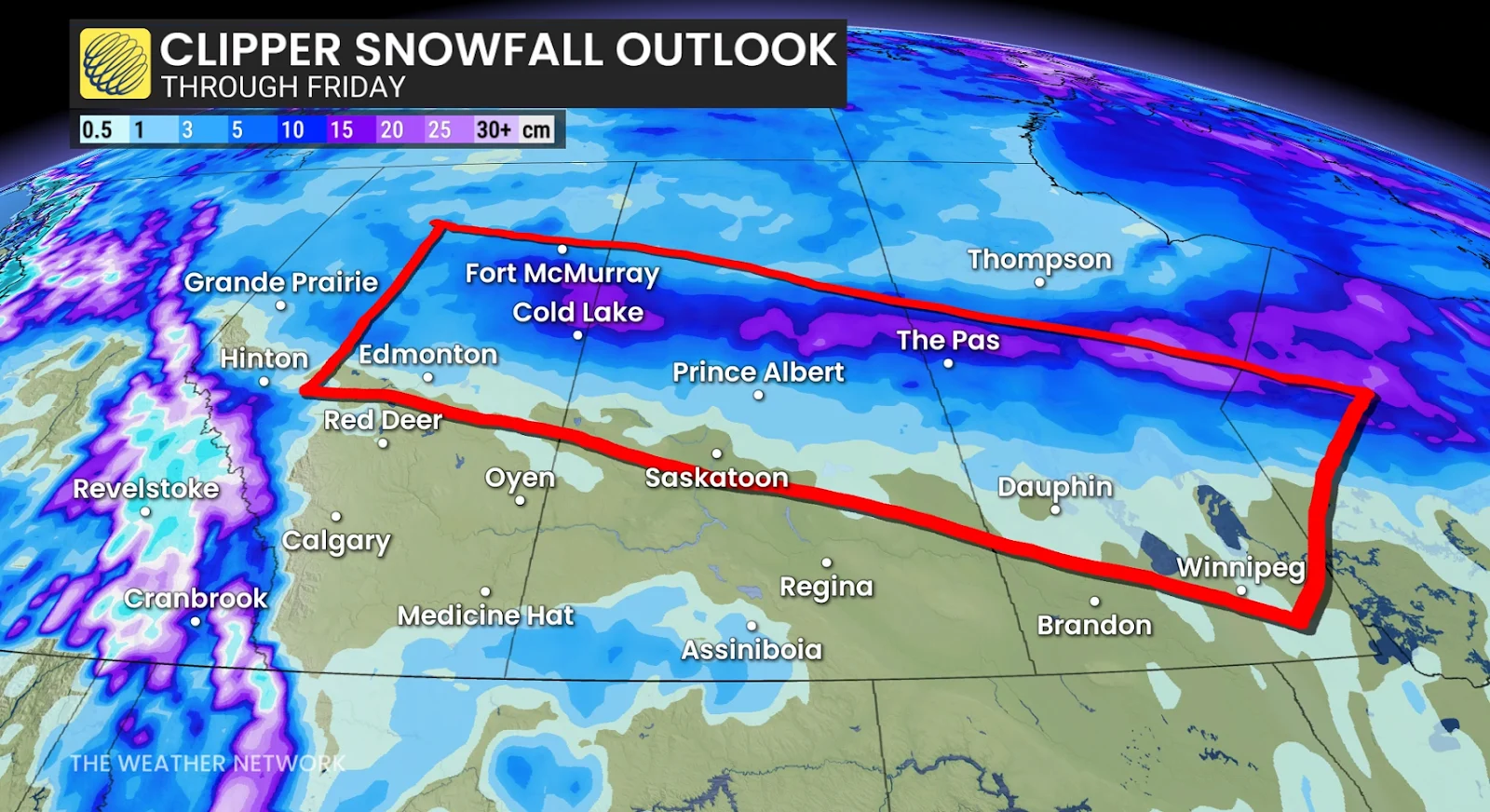
The areas impacted by the snow and the total amounts will be dependent on the clipper system's track, which could change in the coming days, so be sure to check back for updates to the forecast.
Ontario
There will be a few chances for snowfall across Ontario this week, with the first chance forecast on Sunday across the northern region of northwestern Ontario.
The chilliest air will stay put around Hudson Bay, so we'll see the snowfall likely stay north of Thunder Bay and Timmins early in the week.
A subtle shift in the storm track late-week, however, will send the cold air and snow threat south. A low-pressure system will then tap into the chilly air over the Great Lakes, increasing the chances for snow throughout the Great Lakes basin.
DON'T MISS: Why do we 'fall back'?: The story of daylight saving time
WATCH: Why November can be a monster for snow near Canada’s big lakes
Quebec
There will be little shortage of snow in Quebec this week, as most of the province is forecast to see at least a few flakes fall thanks to the cold air over Hudson Bay.
Wet snow is forecast to fall north of Sept-Îles on Monday, and by Tuesday, we'll see the snow threat spread across the Laurentians north of Quebec City. This will be great news for ski resorts in the area, such as Mont-Sainte-Anne and Le Massif de Charlevoix.
By Thursday, we'll see an even chiller burst of cold air move into the province with an upper-level trough, bringing the chance for scattered snow across central regions of the province.
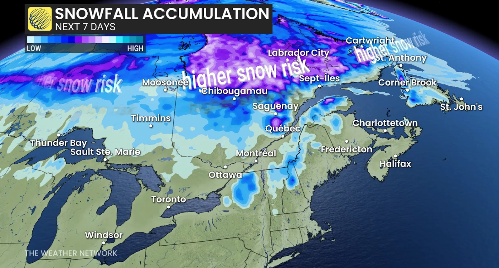
Atlantic Canada
Labrador has already been seeing its fair share of the snow over the weekend, which will continue into the week. We could see some snowfall over western Newfoundland as well.
The Maritime provinces will be focusing on two rainy systems forecast to sweep through the region over the week. Parts of northern New Brunswick do have a chance to see some wet snow as cooler air seeps in from Quebec, but the majority of the province should be in the clear.
The only two provinces not forecast to get any snow this week are Prince Edward Island and Nova Scotia. This is thanks to a mass of mild Atlantic air sitting over the region, keeping out the cold Arctic air that is trying to seep south.
Stay with The Weather Network for more information and updates on your snowy forecast across Canada.