Extreme heat breaks after another shot at rain in parts of Ontario and Quebec
Another chance for rain across parts of Ontario and Quebec on Wednesday followed by a break in the extreme heat that has shaped much of August so far
The end of the week will bring some relief from the very muggy conditions across Ontario, with another shot at rain pushing into the region through Wednesday. That's after some much-needed moisture fell across the south on Tuesday, with reports of locally heavy downpours through the afternoon and evening.
DON'T MISS: Get the latest wildfire news and safety tips to help you stay safe
While the rainfall may provide temporary and localized relief from the ongoing dry and dangerous wildfire conditions, many areas will likely receive less rain than needed to make a significant impact. Storm activity will also vary, leading to a range in precipitation totals across the region.
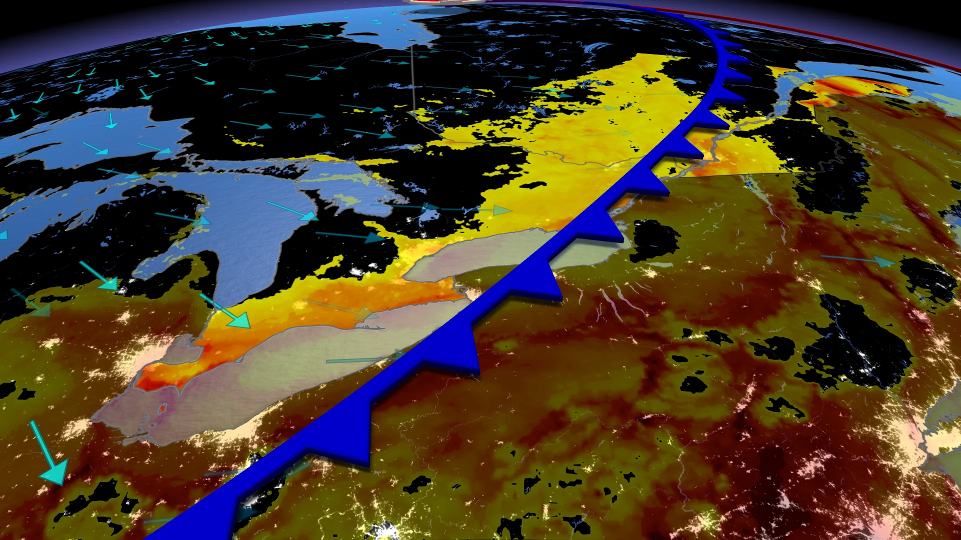
Wednesday: Much-needed rain hits parts of eastern Ontario and Quebec
Southern Ontario received some much-needed rain on Tuesday, but more showers and storms could develop on Wednesday. Afternoon lake breezes may trigger scattered storms from Windsor to Niagara, including parts of the Greater Toronto Area (GTA).
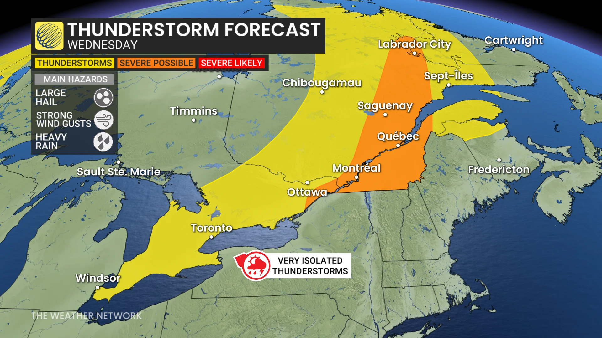
A cold front will move through eastern Ontario into southern Quebec, offering additional rainfall to areas that have seen little to none so far this month. Ottawa (YOW) is in its longest recorded streak without measurable rainfall, currently at 20 days, surpassing the previous record of 18 days. Meanwhile, Montreal (YUL) has recorded just 0.6 mm of rain since July 18—a span of 25 days.
Some storms north of the St. Lawrence could turn severe Wednesday, bringing torrential downpours with localized rainfall of 30-50 mm possible.
More comfortable conditions arrive for Thursday and beyond
By Thursday and Friday, more comfortable conditions are expected, with daytime highs in the high 20s. Humidity levels will, however, make it feel closer to the 30s.

Rain chances remain minimal in the longer range, though showers are possible as early as Sunday.
DON'T MISS: Summer in Canada steams ahead in August, with a few hints of fall
Cooler and less humid conditions are in store for much of Ontario next week. Daytime highs are expected to stay in the low to mid-20s through the first half of the week, while overnight lows could drop into the single digits outside the GTA. Cottage country, in particular, is set for a few chilly nights.
Tropical Storm Erin could play a role in August temperatures
Temperatures could gradually rebound late next week, returning to seasonal averages or even rising a few degrees above seasonal. However, this warm-up may depend on the evolution and track of Tropical Storm Erin. The system’s path could influence the jet stream pattern over eastern North America, potentially affecting how long the cooler weather lingers and when warmer conditions return to the region.
DON'T MISS: Tropical Storm Erin has formed in the Atlantic, and will be one to watch
Residents are advised to monitor forecasts for updates on Erin’s progress and its potential effects on weather trends in eastern Canada.
WATCH: Extremely dry conditions fuelling wildfires in southern Ontario
Be sure to check back for the latest weather updates across Ontario.