300 km/h: Hurricane Melissa nears intensity limits, brings 'catastrophic' impact
Catastrophic situation unfolding as Hurricane Melissa threatens Jamaica with days of intense destructive winds and heavy rainfall
Stay up-to-date with all hurricane developments on The Weather Network's tropical storm hub page.
Weather Highlights:
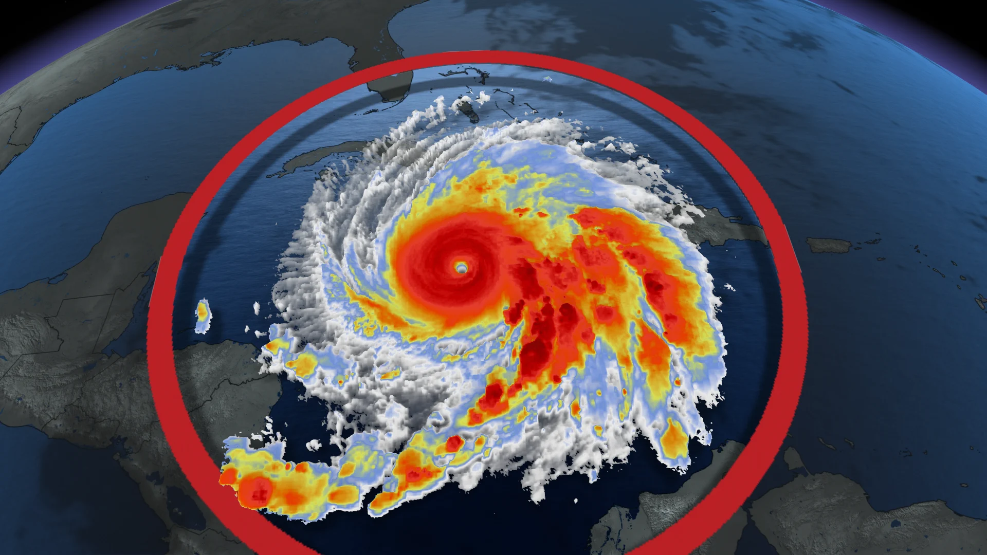
Hurricane Melissa remains a powerful, Category 5 hurricane
Melissa will make landfall on Jamaica Tuesday, possibly as a Category 5 hurricane still
Life-threatening and catastrophic flash flooding, winds and storm surge expected in Jamaica and southern Hispaniola
Hurricane warning extended to southeastern and central Bahamas
All attempts to secure life and property should be completed. Tourists in the region are urged to heed the advice of local officials

Category 5 Hurricane Melissa makes landfall over Jamaica Tuesday
Hurricane Melissa is anticipated to cause significant impacts as it makes landfall in Jamaica Tuesday, bringing storm surges, flash floods, and landslides. According to a U.N. weather official, this could be the most severe storm to affect the Caribbean island this century.
RELATED: Airports close as Jamaica braces for potentially catastrophic Hurricane Melissa
On the forecast track, Hurricane Melissa's core is projected to pass over Jamaica Tuesday, move over southeastern Cuba by Wednesday morning, and reach the southeastern or central Bahamas later on Wednesday.
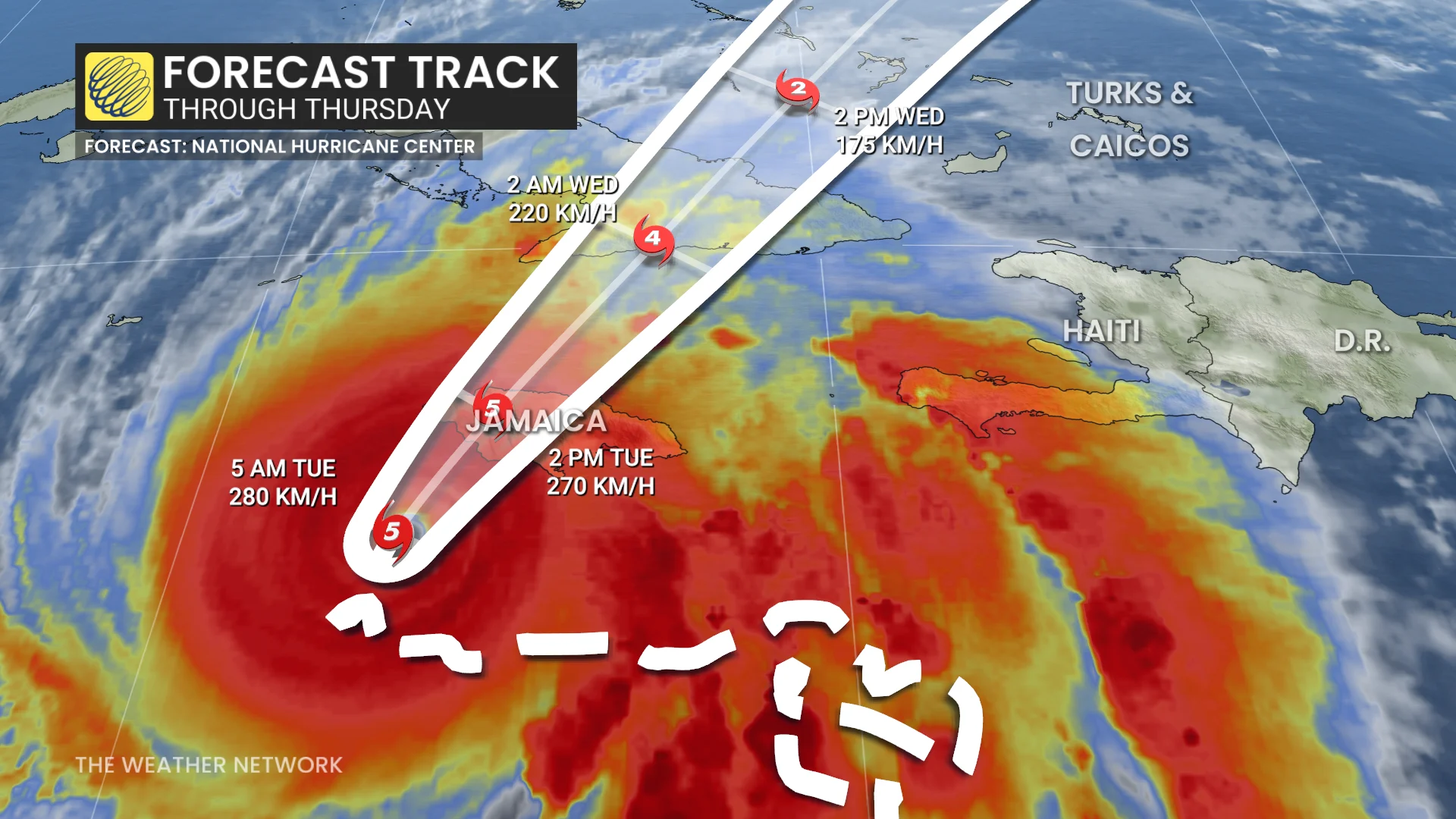
Melissa's intensity may fluctuate before making landfall in Jamaica, however, it is expected to reach Jamaica and southeastern Cuba as an extremely dangerous major hurricane and remain at hurricane strength as it moves across the southeastern Bahamas.
With the additional strengthening seen on Monday, Melissa is now the strongest global storm of the year so far--ahead of the devastating Super Typhoon Regasa--a large, powerful and deadly tropical cyclone. Melissa has maintained major Category 5 status since 5 a.m. on Monday.

SEE ALSO: Melissa to remain a major hurricane with second landfall over Cuba
This also marks the third Category 5 storm of the 2025 Atlantic hurricane season, a rare occurrence only exceeded by the 2005 season, which saw four similar systems.
According to the U.S National Hurricane Center (NHC), Melissa's slow movement over unusually warm Caribbean waters has significantly increased its size and strength, putting Jamaica at risk of enduring days of intense destructive winds and heavy rainfall.
DON'T MISS: Canadian impact? All eyes on Hurricane Melissa after its Jamaica landfall
Local storm totals could reach 1,000 mm
Hurricane Melissa is forecast to deliver 380 to 760 mm of rainfall to parts of Jamaica, with additional amounts of 150 to 300 mm expected for southern Hispaniola through Wednesday. Local storm totals could reach 1,000 mm, leading to catastrophic flash flooding and numerous landslides.

For eastern Cuba, storm totals of 250 to 500 mm are anticipated, with local amounts up to 635 mm possible by Wednesday. This could result in life-threatening flash flooding and widespread landslides.
Rainfall is also expected to develop later Tuesday over the southeastern Bahamas and the Turks and Caicos and continue into Wednesday, with totals of 125 to 250 mm. Flash flooding is likely in some areas.

DON’T MISS: A stalled hurricane can produce disastrous flash flooding
The storm’s forecast path will bring significant impacts to low-lying, densely populated areas along Jamaica's south coast, with storm surge and flooding presenting major hazards. Mountainous regions will also face elevated risks of landslides.
Melissa’s eye wall, carrying the most intense winds, is expected to pass directly over the island. Canadian authorities have issued travel advisories for the region.
WATCH: Residents urged to leave ahead of dangerous storm surge
Jamaica's strongest hurricane in 37 years
This will be Jamaica's strongest hurricane since Gilbert in 1988, which caused 49 fatalities and devastated the island with over 800 mm of rainfall, triggering landslides and widespread power outages.
Gilbert made landfall in Jamaica as a Category 4 hurricane.

Storm surge threatens destructive waves
Peak storm surge heights could reach 2.7 to 4 metres above ground level, particularly near and east of Melissa's landfall location. This surge will be accompanied by large, destructive waves.
RELATED: What is a hurricane storm surge, and why is it so dangerous?
As well, there is a potential for significant storm surge along the southeast coast of Cuba late Tuesday or Wednesday. Peak storm surge heights could reach 2.13 metres to 3.35 metres above normal tide levels, near and to the east of where the centre of Melissa makes landfall.
Stay updated on alerts and evacuation orders, as the situation remains highly dangerous.
Canadian impacts? Stay alert
Melissa is forecast to move along the U.S. Eastern Seaboard through mid to late week before likely heading out to sea.
RELATED: What does a hurricane’s ‘cone of uncertainty’ mean?
There is potential for some of its moisture and energy to transfer to a developing East Coast low, which could result in heavy rainfall for parts of eastern Canada around Halloween.
Stay with The Weather Network for all the latest updates on the tropics.