12-14 days without rain: B.C.'s rare winter dry streak comes to an end

After up to 14 consecutive days without rain, a rare winter dry streak across southern B.C. is finally ending. A shift in the jet stream is bringing mild Pacific air, resulting in significant rainfall and above-seasonal temperatures.
The rare winter dry streak in B.C. will finally come to an end this week.
It’s been two weeks since some regions of the South Coast of British Columbia last reported a drop of rain.
SEE ALSO: B.C’S ridge paradox: Why record warmth won’t feel warm
A stubborn ridge of high pressure refused to quit, first building over the Pacific Northwest mid-January, amplifying over Alaska, and re-establishing itself across the eastern Pacific through the past week.
But that is all about to change this week.
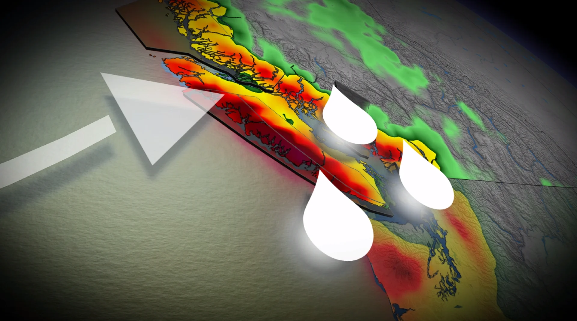
A long-overdue pattern change is forecast
The dry streak and warmth triggered the cherry blossoms weeks ahead of schedule, and triggered ski resorts to resort to moving and making snow to protect the snowpack.
Finally, a typical Gulf of Alaska low moves it, providing a more robust, onshore flow.

A series of Pacific frontal systems will sweep across the South Coast, beginning Tuesday evening and overnight.
The first wave through Wednesday is modest with 5-15 mm across lower elevations, but higher amounts across higher terrain.
By Wednesday night, a more classic frontal system crosses the region, providing soaking rainfall - potentially lingering through much of Thursday.

A stormy signal persists through Friday with continued onshore flow.
Rainfall outlook:
Tofino: 200+ mm
North Vancouver: 100 + mm
Lower Mainland: 50-75 mm (locally lower and higher due to rain shadow)
East Vancouver Island: 30-50+ mm
Greater Victoria: 10-30 mm

Freezing level: skiers hold their breath
Falling to 1300 metres by Wednesday morning, freezing levels will remain below 1500 metres through Thursday morning.
Signs of a rising freezing level into the Thursday evening-Friday morning system, higher than 1600 metres, but lower freezing levels are forecast in the Interior.
It’s important to note that the snowpack doesn’t normally peak until April across the South Coast.

RELATED: What is a 'freezing level', exactly?
Central Vancouver Island is currently sitting at about 50 per cent of normal at around 1500 metres elevation.
Consecutive days without measurable rain as of Jan. 26
VANCOUVER (YVR)
Current streak: 12 consecutive dry days (Jan. 15–26)
Historical context:
2025: 12 consecutive January dry days (Jan. 17-29)
2014: 15 consecutive January dry days (Jan. 13-27)
VICTORIA (YYJ)
Current streak: 12 consecutive dry days (Jan. 15-26)
Historical context:
2025: 19 consecutive January dry days (Jan. 11–29)
2014: 15 consecutive January dry days (Jan. 13–27)

COMOX (YQQ)
Current streak: 14 consecutive dry days (Jan. 13–26)
Historical context:
2025: 13 consecutive January dry days (Jan. 17–29)
2014: 14 consecutive January dry days (Jan. 13–26) — ties current streak
ABBOTSFORD (YXX)
Current streak: 11 consecutive dry days (Jan. 16-26)
Historical context:
2025: 18 consecutive January dry days (Jan. 12–29)
2014: 14 consecutive January dry days (Jan. 14–27)
2009 also featured an extraordinary, prolonged dry streak with very little precipitation over two weeks.
The ridiculously resilient ridge will finally depart after anchoring along the coast of B.C. for the past couple of weeks. It was the pattern brought days of fog across lower elevations and a stubborn inversion that lingered for days on end.
WATCH: Pattern change ahead for B.C., but will It be snow or rain?
Stay tuned to The Weather Network for the latest forecast updates for B.C.