
100+ km/h winds: Explosive 'weather bomb' is brewing for Atlantic Canada
Rapidly intensifying storm to impact Newfoundland Tuesday with strong winds, heavy rain, and potential snow. Wind warnings in effect
Weather Highlights:
A rapidly intensifying November storm is set to impact the Maritimes on Monday night with heavy rain and winds of 60-80 km/h, reaching Newfoundland on Tuesday morning and intensifying to a weather bomb by evening.
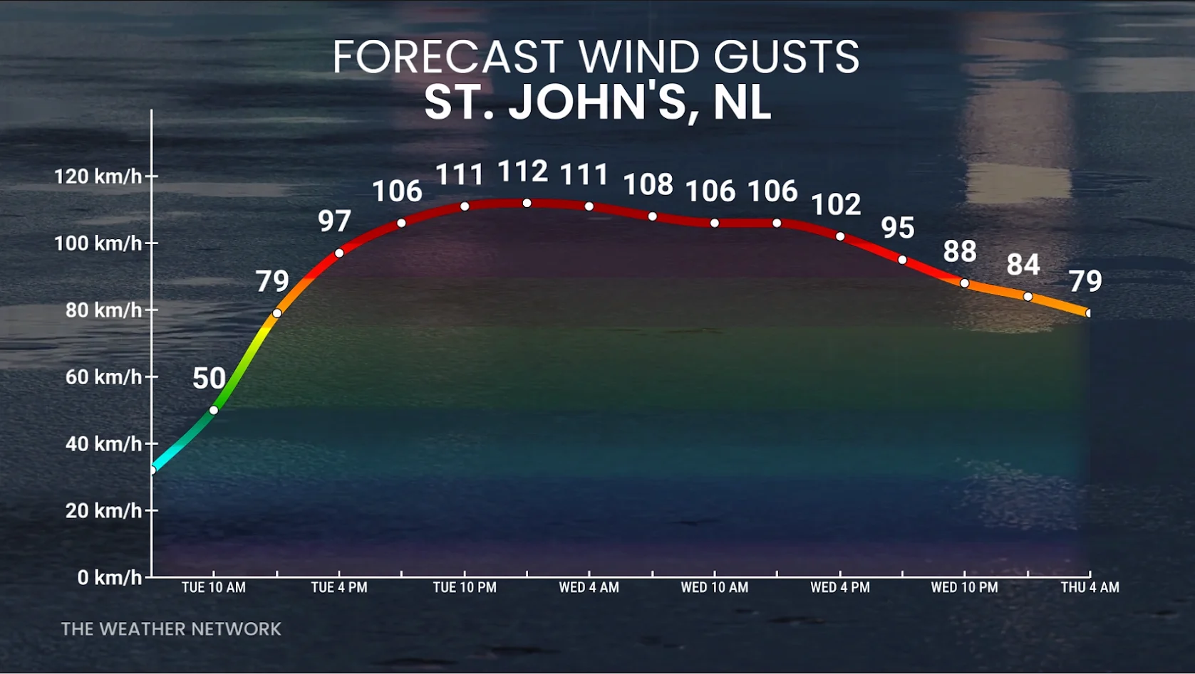
Eastern Newfoundland will see the strongest winds, with gusts of 90-100+ km/h, and over 110 km/h near Sable Island and southeastern coasts, including St. John’s and the Avalon. Wet snow may occur in higher elevations of western Newfoundland and Labrador.
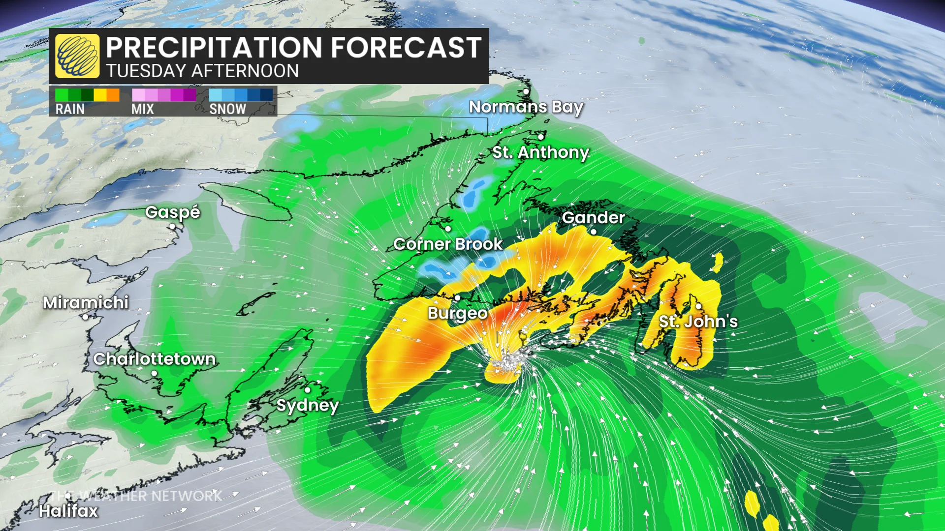
Rainfall of 30-75 mm is expected across parts of Newfoundland and Cape Breton, posing risks for power outages, downed trees, localized flooding, coastal erosion, and large waves reaching 7-8 metres.

A significant November storm is developing, showing signs of a rapidly intensifying weather system. By Monday afternoon, a deep, cut-off trough will interact with the warm waters of the Gulf Stream, generating a sharp temperature contrast between the ocean and the air.
Within 24 hours, a powerful low pressure system is expected to approach Newfoundland.
RELATED: Are you ready for 'Snow'vember? Snowfall threat looms over Canada
The storm will likely undergo bombogenesis-–a rapid deepening that turns the storm into a formidable low as it approaches Newfoundland on Tuesday.
Intense wind gusts, heavy rainfall and maybe even some snowfall are all on the table.
The set up: Ingredients brewing for a powerful Newfoundland 'weather bomb'
Low pressure is expected to develop late Monday off the coast of the Mid-Atlantic states and rapidly intensify as it tracks to or just south of Atlantic Canada.
DON'T MISS: 'Weather bombs': Explosive storms that create ferocious conditions
This region is the spark plug for the development of low pressure, but the secret ingredient is lurking upstream in Canada. The real intensification begins when energy from the southern trough starts to phase with a second trough diving towards the Maritimes. When those two upper-level systems merge, it creates a strong lift in the atmosphere, pulling air upward and deepening the surface low below.
Think of this as storm ventilation; the lift creates an opportunity to deepen the low at an explosive rate.
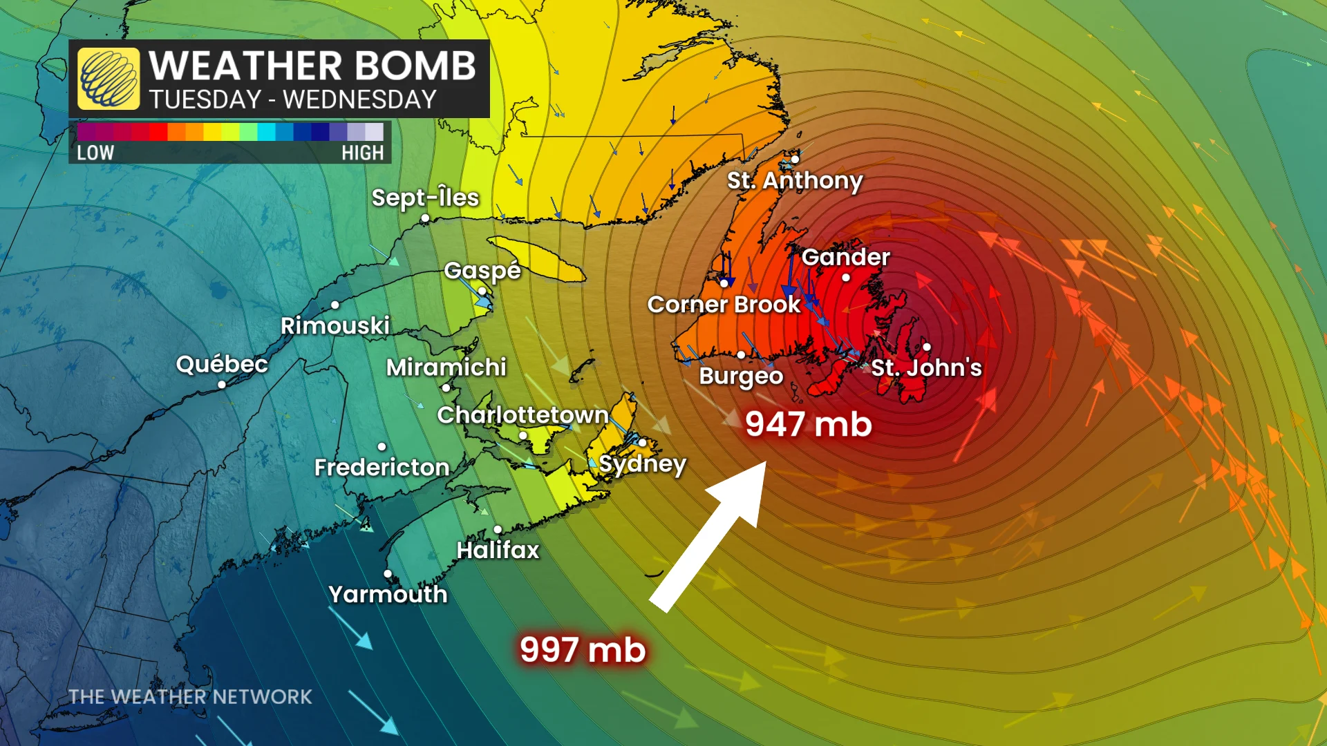
At the surface, this triggers rapid pressure falls south of the Maritimes Monday night. As the developing storm sits in a sweet pocket with ideal upper-level support, the pressure will continue to fall--all signs of an impressive 'weather bomb' being born.
Sea surface temperatures along the northern edge of the Gulf Stream are remarkably warm for early November, hovering in the low 20°C range just offshore of Nova Scotia and Newfoundland.
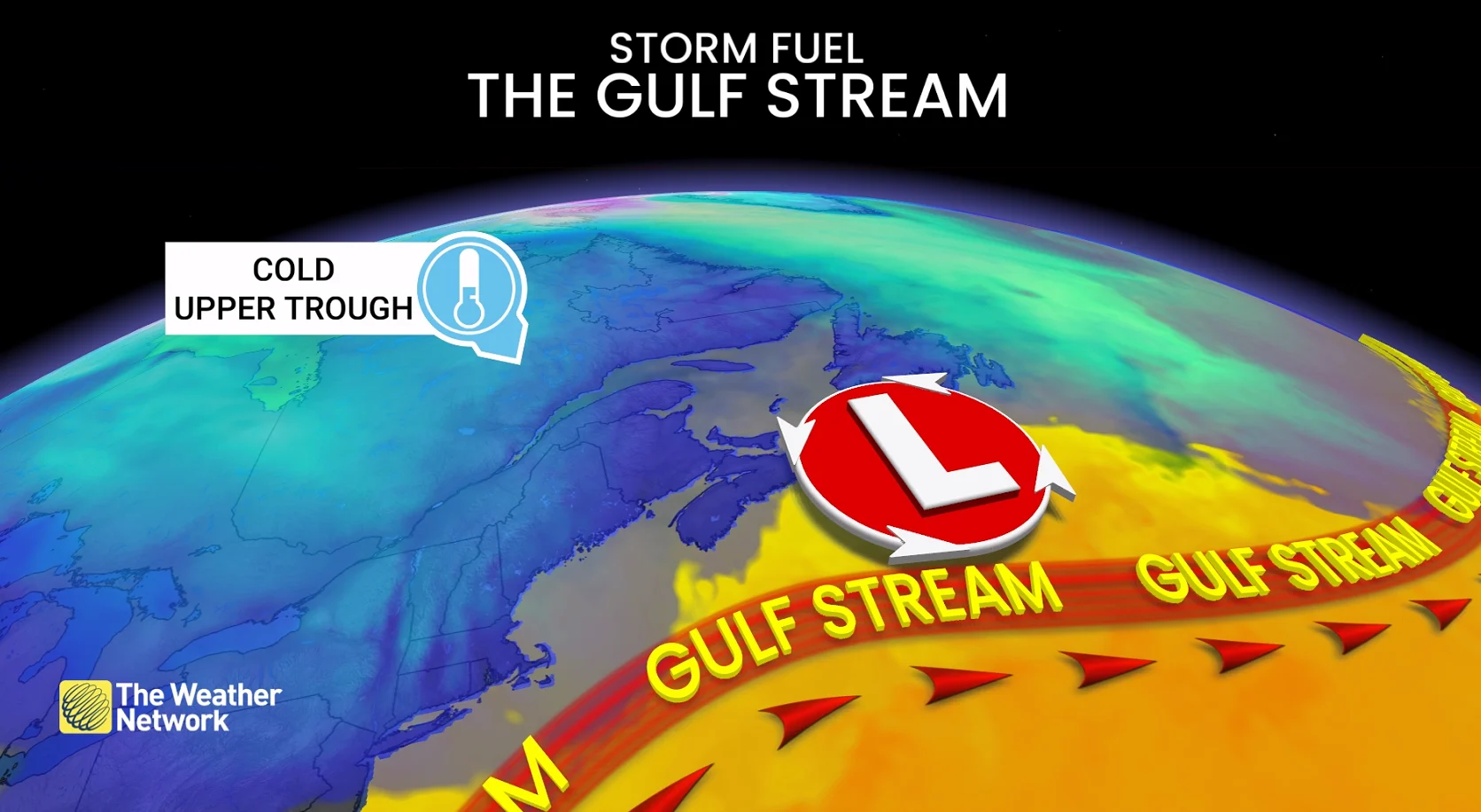
As the cold upper trough passes over the ocean, the sharp contrast in temperatures triggers convection and grows the storm vertically. Mid-latitude storms thrive on this zone of Arctic air and tropical moisture farther south.
Explosive deepening recipe
Phasing upper troughs
Warm Gulf Stream waters (20°C to 22°C)
Cold air supply from Canada
Strong jet stream support aloft
Timing the impacts, brace for outages:
Heavy rain and gusty winds of 60-80 km/h will impact the Maritimes on Monday night, with weather effects reaching Newfoundland by Tuesday morning.
Conditions will intensify as the low pressure system deepens to approximately 945 mb by Tuesday evening, just south of the province.
DON'T MISS: Canada’s November features extended fall, but winter lurks on the sidelines
Winds will be strongest along the south, east, and north coasts of Newfoundland, with gusts of 90-100+ km/h.
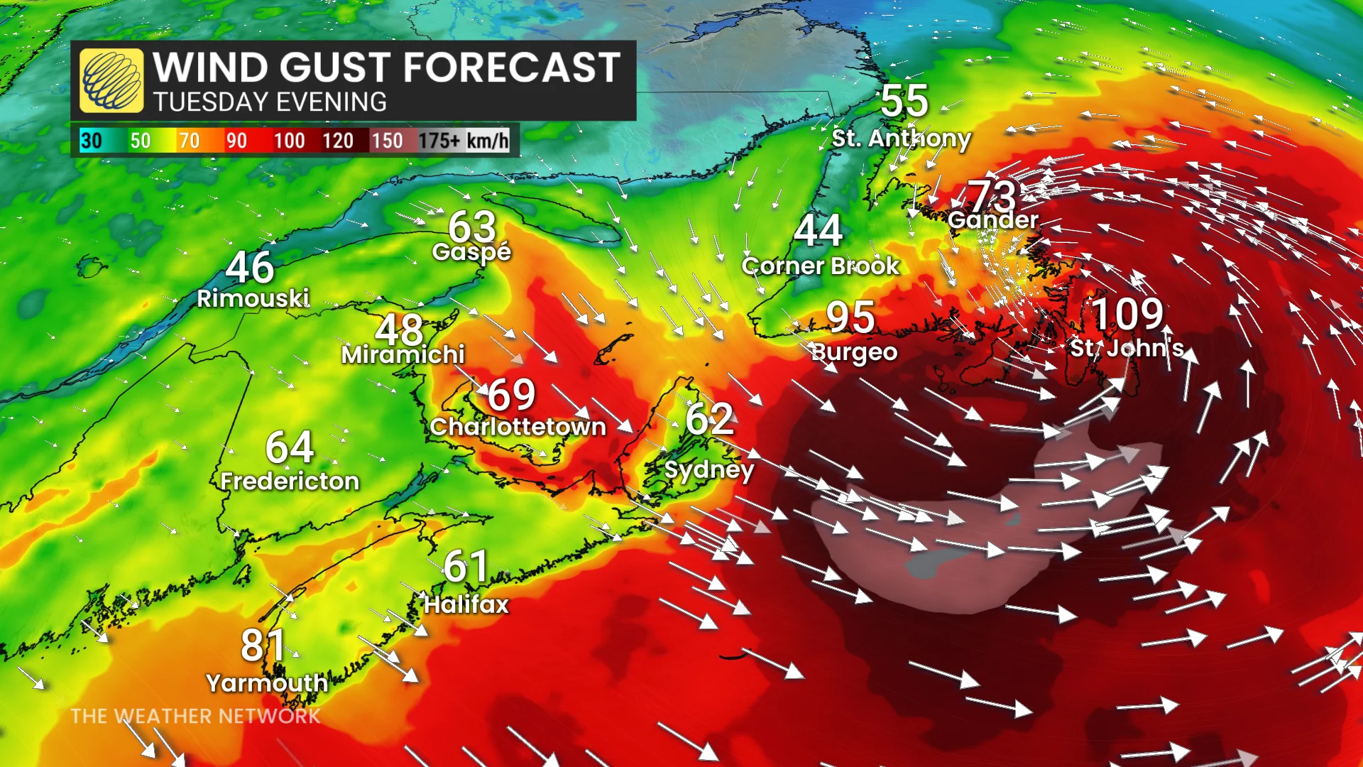
Gusts exceeding 110 km/h are possible, especially around Sable Island and southeastern coastal Newfoundland, including St. John’s and the Avalon Peninsula. Wind warnings are in effect.
The most recent gust over 100 km/h in St. John’s occurred on February 15, while the last gust exceeding 110 km/h was recorded on January 5.
Wet snow may also develop in higher elevations in western Newfoundland and Labrador.
Localized flooding and coastal erosion a threat
Rainfall accumulations of 50-75 mm are expected in Cape Breton and along the Burgeo coast, with widespread amounts of 30-50 mm across the Avalon Peninsula.
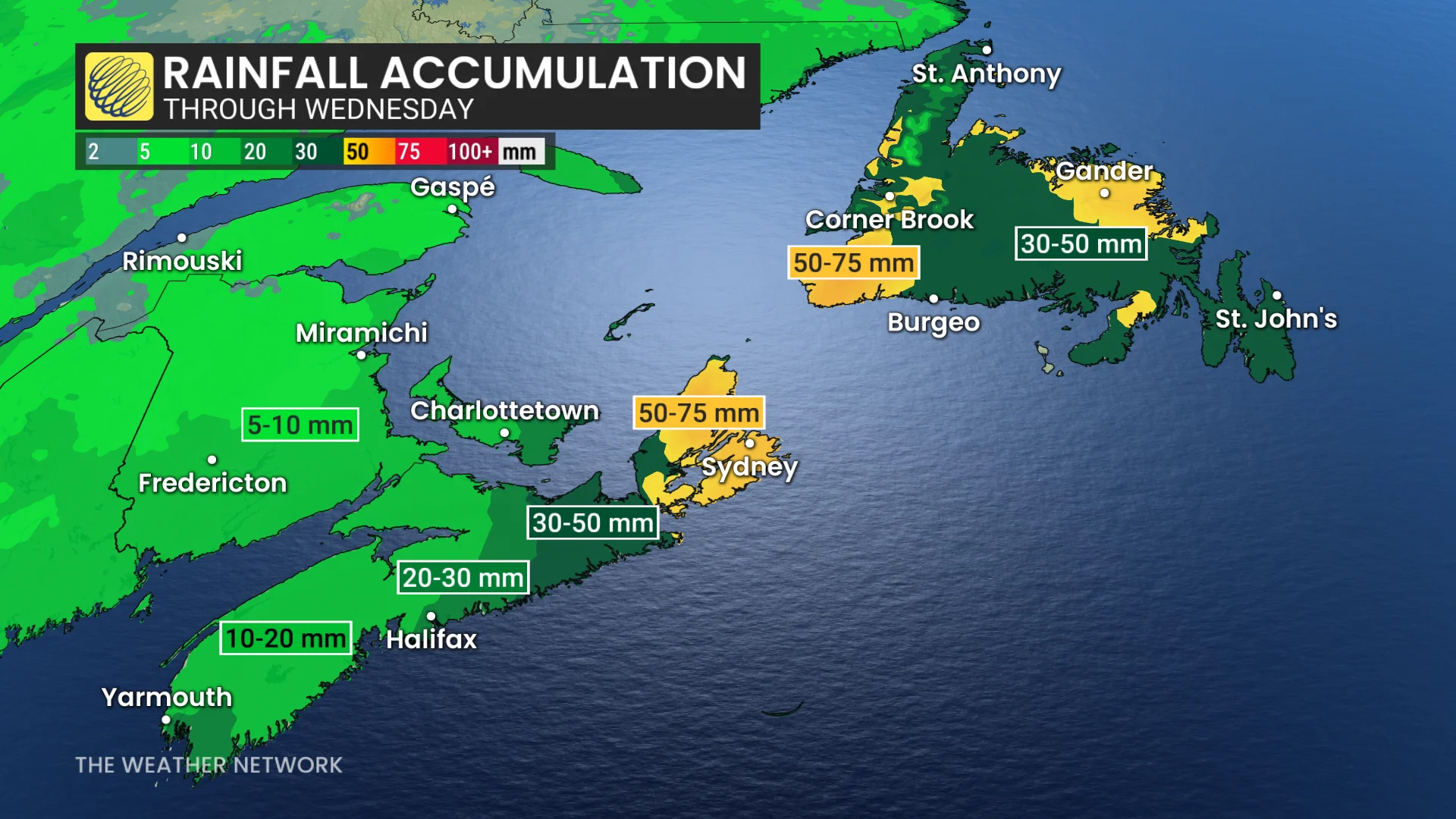
Impacts may include power outages, downed trees, minor structural damage, localized flooding in Cape Breton and Newfoundland, as well as coastal erosion due to large waves reaching 7-8 metres.
Stay updated as this system develops. Weather conditions may present risks for travel and infrastructure in the region.
WATCH: How a 'weather bomb' forms and what it means
Stay tuned to The Weather Network for the latest forecast updates for Atlantic Canada.