The high-stakes factors that decide where a hurricane tracks

Many factors determine the ultimate track of a hurricane across the Atlantic Ocean
Hurricane forecasts are more accurate today than ever before—and much of that improvement stems from the track of a storm itself.
These forecast advances are even more impressive when you consider just how many factors play into the ultimate path of a hurricane as it traverses the Atlantic Ocean.
DON'T MISS: Visit The Weather Network's hurricane hub to keep up with the latest on tropical developments in Canada and around the world
Strength of a storm helps determine its track
What drives a hurricane? Lots of moving parts determine where a storm may travel as it treks across the vast expanse of the ocean.
Lacking any winds to steer the storm along, a hurricane in the northern hemisphere naturally drifts toward the northwest due to Coriolis forces.
But the atmosphere is rarely calm. There’s almost always a steering current that helps push the storm along in one direction or another.

The strength of a tropical cyclone can determine whether winds in the lower levels or the upper levels of the atmosphere will steer the storm along.
A weaker tropical cyclone often features less robust, shallower thunderstorms that allow low-level winds to blow the system along.
Stronger tropical storms and hurricanes, on the other hand, can feel the influence of winds through a deeper layer of the atmosphere as their thunderstorms are taller and healthier.
It may not seem like much, but it can mean the difference between a storm drifting west toward land or curving back out to sea.
Trade winds, Atlantic highs are the main drivers
Trade winds are responsible for carrying tropical waves off the coast of Africa and blowing them west across the Atlantic Ocean.
But where does a storm go after that?
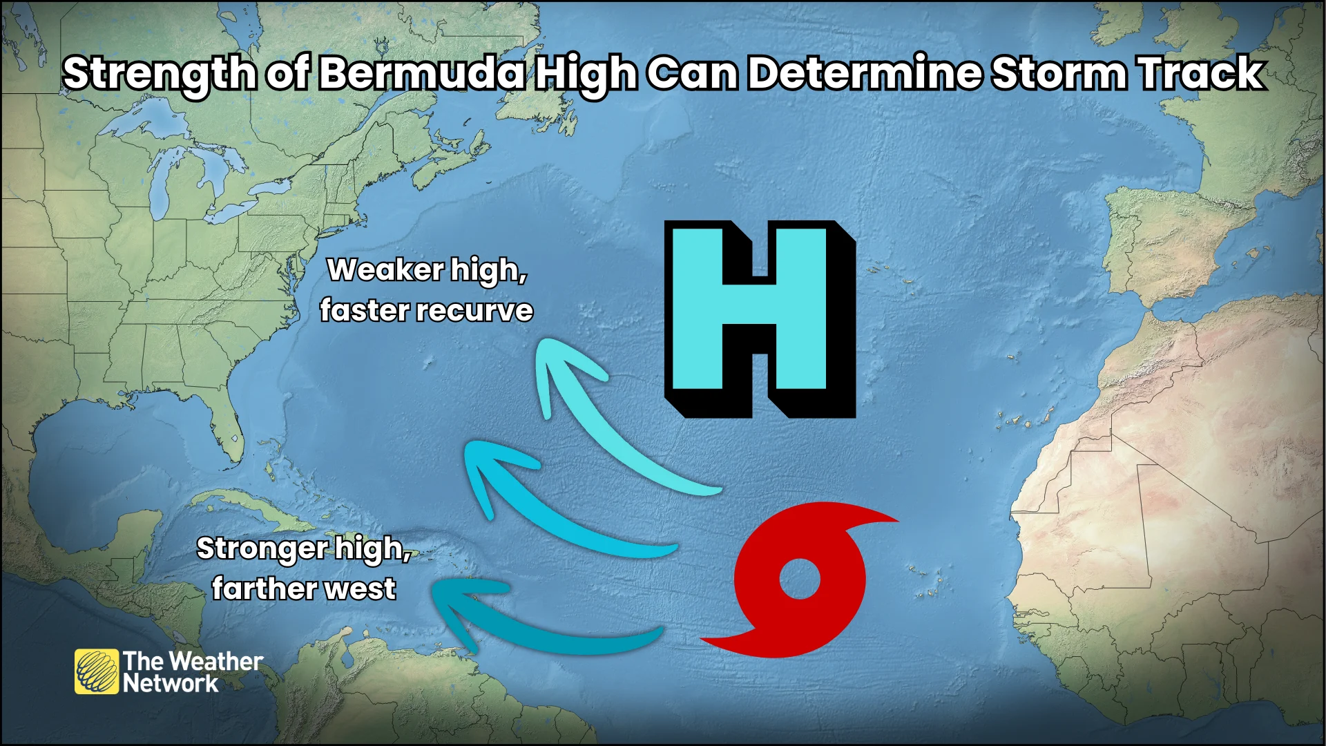
A large centre of high pressure over the central Atlantic known as the Bermuda High is the dominant driving force when it comes to the path of tropical storms and hurricanes. The outer edge of this high acts like a guardrail that prevents storms from immediately curving out to sea.
MUST SEE: How spaghetti models and cones help refine your forecast
The position and strength of the high are major factors in determining the track of a storm.
Storms can move into the Caribbean, the U.S., and even Atlantic Canada when the Bermuda High is strong and parked farther west. A weakness in the ridge, or a ridge that sets up farther east over the ocean, can provide a storm an ‘escape route’ of sorts and allow it to turn harmlessly out toward open waters.
Additional ridges of high pressure over the United States, Atlantic Canada, and Greenland can also steer or block storms, influencing their track. A blocking high can even force a hurricane to stall out—this is what happened with Hurricane Harvey in Texas back in 2017.
Troughs of low pressure can also push and pull on a storm, sweeping them out to sea or sometimes grabbing the storm and swinging it back toward land. We saw this scenario play out during Hurricane Sandy in 2012, and again during Hurricane Fiona in 2022.
Header image created using graphics and imagery from NOAA and Canva.