Straits: How these geographic gateways keep the economy moving

These narrow zones are some of the most important locations for the global economy
Straits are a vital part of the global shipping network. Vast swaths of goods and natural resources transported by sea pass through these narrow passages every day.
Despite the vastness of our open seas, the ability to quickly travel from point to point relies on a handful of tiny chokepoints near land. But why do these straits exist in the first place?
DON’T MISS: How seawater and limestone could be used to reduce maritime emissions
What is a strait?
A strait is a narrow channel that connects two larger bodies of water. These waterways, bounded on either side by land, can range in size from incredibly large to just a few kilometres across.

Most straits are the result of tectonic activity as continental plates drift together; we just happen to exist in the brief window of Earth’s life before those continents collide. Others, like the Bosphorous Strait and Øresund Strait, formed through processes like erosion or sea-level rise.
Canada has numerous prominent straits, including British Columbia’s Strait of Georgia and the Northumberland Strait separating Prince Edward Island and New Brunswick.
Several straits around the world are absolutely critical to everything from cruise ship routes to the movement of trillions of dollars in goods and resources.
Strait of Hormuz
The Strait of Hormuz connects the Persian Gulf to the Indian Ocean. Measuring around 40 km wide at its narrowest point, this waterway is bounded by Iran to the north and Oman’s Musandam Peninsula to the south.

Formed over millions of years as the Arabian Plate drifts toward the Eurasian Plate, a significant percentage of the world’s liquefied natural gas and crude oil pass through the Strait every year.
Disruptions due to regional tensions can prove costly. It's impossible to bypass the region with a canal, as many folks online often suggest. Mountains on the Musandam Peninsula climb as tall as 2,000 metres in elevation.
Bab al-Mandab Strait
Sitting on the other side of the Arabian Peninsula, the Bab al-Mandab Strait proves to be one of the world’s most strategically important waterways.
This passage between Yemen and Djibouti connects the Red Sea to the Indian Ocean, allowing ships to bypass a trip around Africa by accessing the Suez Canal.
The Bab al-Mandab Strait formed when sea level rise millions of years ago closed off a narrow isthmus between Africa and the Arabian Peninsula.
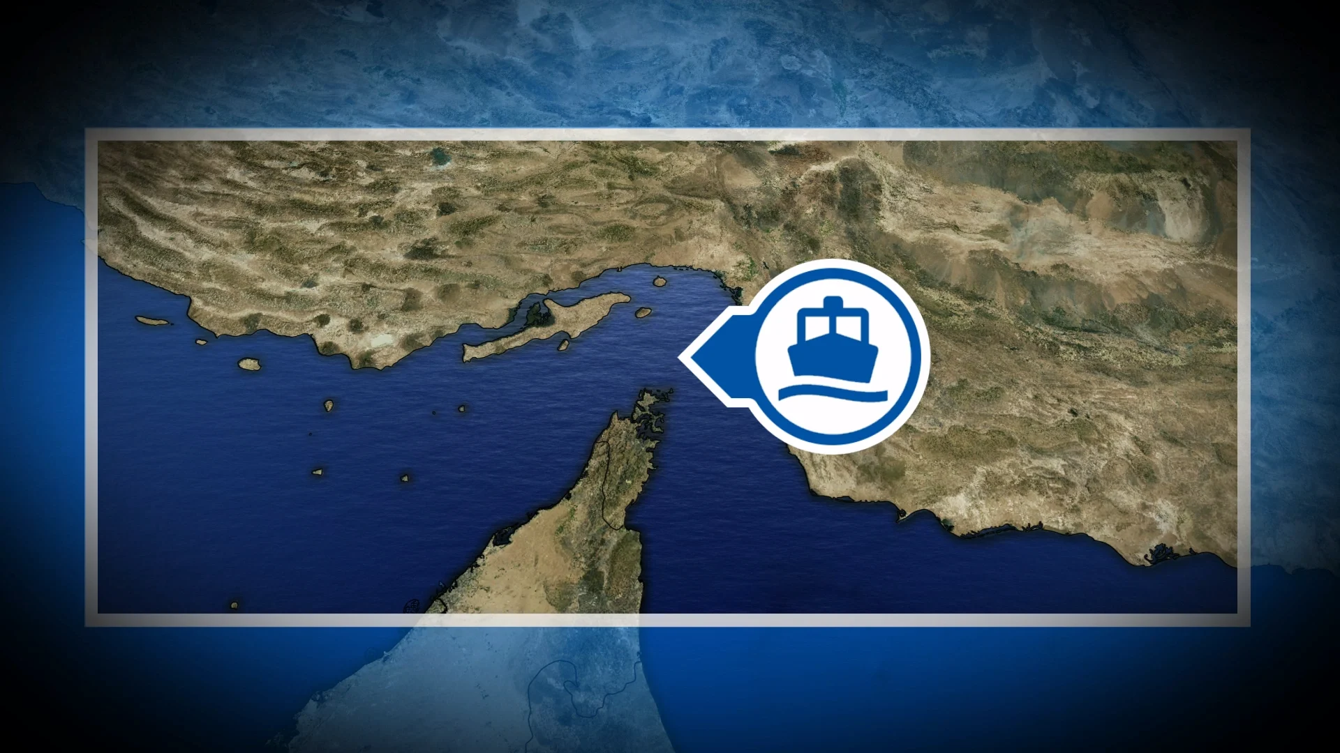
Strait of Gibraltar
Only 14 kilometres separate the tip of Europe’s Iberian Peninsula from the coast of northwestern Africa, a narrow expanse of water known as the Strait of Gibraltar.

Not only does this Strait hold the key to passage between the Mediterranean and the Atlantic Ocean, but the region is also home to one of the world’s most fascinating weather phenomena.
Gibraltar is a British overseas territory situated on a pencil-like peninsula along Spain’s southern coastline. The small city sits at the foot of a large limestone monolith.
Banner clouds are a common sight on the Rock of Gibraltar as moist oceanic winds flow up and over the monolith, making it one of Europe’s most iconic and unique locations.
The Suez Canal
Natural straits are a lucky break for ships hoping to cut down on the time and danger involved in intercontinental travel. Humans have occasionally stepped in to make passage even easier at a few key points.

RELATED: Cargo vessels could one day be powered by wind energy, company says
Ships traversing the Red Sea on their way to the Mediterranean eventually have to pass through the Suez Canal. Hundreds of thousands of labourers dug this canal in northeastern Egypt during the mid-1800s.
Many millions of metric tons of cargo travel through the Suez Canal every year without much notice.
We certainly felt the importance of this passage when a ship got stuck in the Canal for almost a week in late-March 2021. The incident disrupted worldwide supply chains for months afterward.
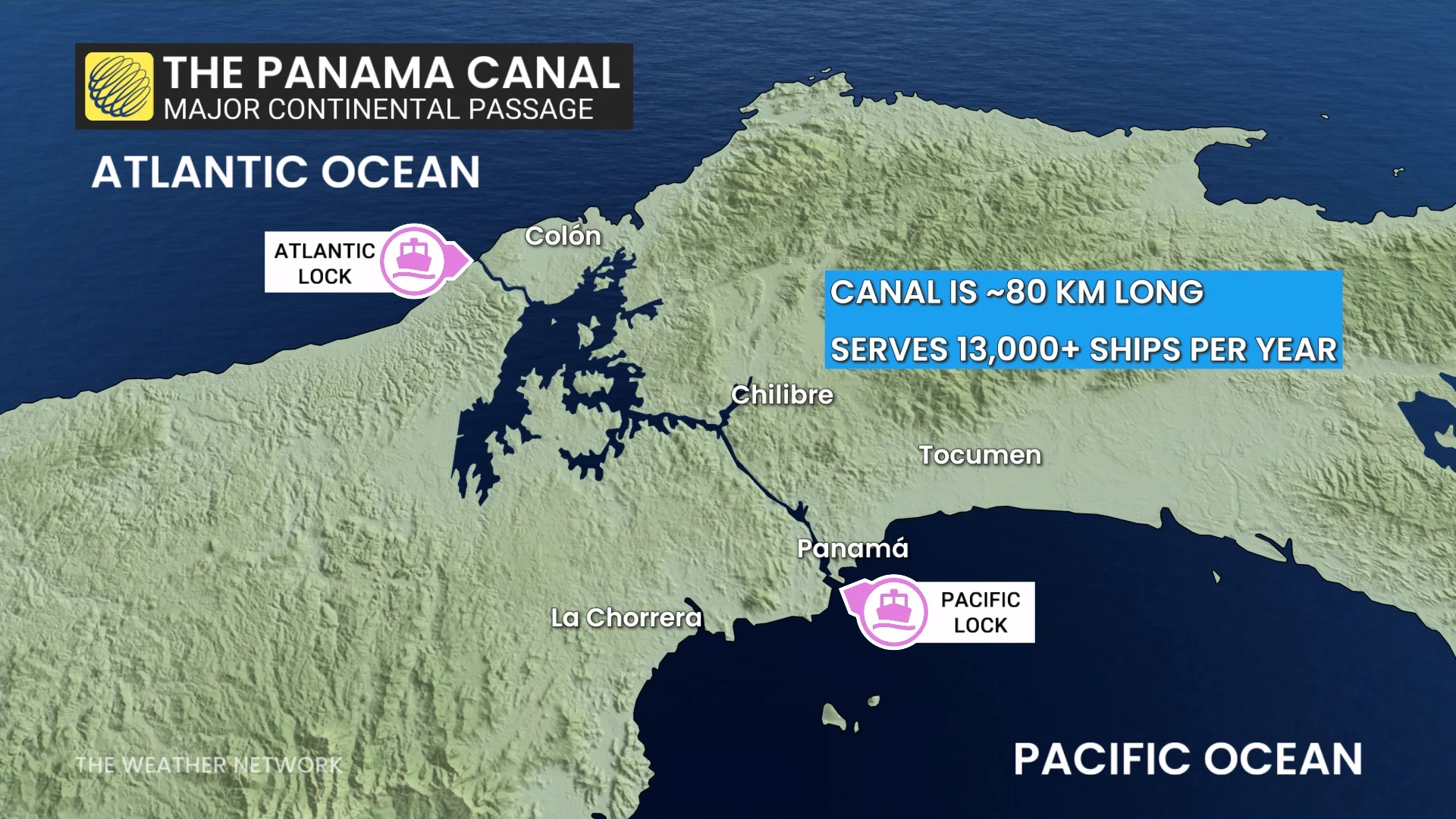
The Panama Canal
One of the most impressive technological achievements came at a tremendous human cost.
Tens of thousands of labourers died from disease or injury during construction of the Panama Canal in the early 1900s.
Crews couldn’t simply dig a canal through the Panamanian jungle. Steep elevation changes required an intricate system of locks to raise and lower ships travelling between each ocean.
The Panama Canal measures about 80 km long and it takes an average of about 12 hours for a ship to pass from one side to the other.